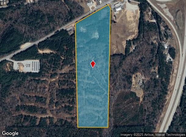
Property Record
S Highway 29, Grantville, GA 30220
Current Lease Availabilities
NEARBY LISTINGS FOR SALE OR LEASE
-
-
View all Grantville listings for lease on LoopNet.com
Property Detail
S Highway 29
G08-2246-011
39.90 AC LL246 GRANTVILLE
Commercialnec
Coweta
X
Georgia
13077C0352D
39.97 AC
2025
Fayette/Coweta County
2025
Atlanta
170801
Atlanta-Sandy Springs-Roswell, GA
DEMOGRAPHICS near S Highway 29
1 Mile
3 Mile
5 Mile
2024 Total Population
764
4,535
9,174
2029 Population
859
5,047
10,066
Pop Growth 2024-2029
+ 12.43%
+ 11.29%
+ 9.72%
Average Age
39
38
40
2024 Total Households
288
1,656
3,405
HH Growth 2024-2029
+ 12.50%
+ 11.41%
+ 9.75%
Median Household Inc
$75,893
$73,403
$69,912
Avg Household Size
2.60
2.70
2.70
2024 Avg HH Vehicles
2.00
2.00
2.00
Median Home Value
$207,447
$186,969
$202,138
Median Year Built
1999
1998
1995
Nearby Places
- Restaurants
- Banks
- Shops
- Fitness
- Groceries
Nearby Properties
Address
Land Use
TOTAL SIZE
Lot Size
Zoning
Address
Land Use
TOTAL SIZE
Lot Size
Zoning
69,742 SF
20.83 AC
R2
Address
Land Use
TOTAL SIZE
Lot Size
Zoning
1,804.34 AC
001
Address
Land Use
TOTAL SIZE
Lot Size
Zoning
27,839 SF
10 AC
R2
Address
Land Use
TOTAL SIZE
Lot Size
Zoning
29,936 SF
4 AC
R1
Address
Land Use
TOTAL SIZE
Lot Size
Zoning
864 SF
95.70 AC
RFA
Address
Land Use
TOTAL SIZE
Lot Size
Zoning
27.11 AC
R1
Address
Land Use
TOTAL SIZE
Lot Size
Zoning
15,156 SF
4.05 AC
R1
Address
Land Use
TOTAL SIZE
Lot Size
Zoning
25.39 AC
C2
Address
Land Use
TOTAL SIZE
Lot Size
Zoning
196.43 AC
R1
Address
Land Use
TOTAL SIZE
Lot Size
Zoning
19,676 SF
5 AC
001
Address
Land Use
TOTAL SIZE
Lot Size
Zoning
36.56 AC
C2
Address
Land Use
TOTAL SIZE
Lot Size
Zoning
29.56 AC
C2
Address
Land Use
TOTAL SIZE
Lot Size
Zoning
8,000 SF
2.39 AC
R1
Address
Land Use
TOTAL SIZE
Lot Size
Zoning
352.51 AC
001
Address
Land Use
TOTAL SIZE
Lot Size
Zoning
3,150 SF
1.27 AC
R1
Address
Land Use
TOTAL SIZE
Lot Size
Zoning
5,356 SF
1.70 AC
001
Address
Land Use
TOTAL SIZE
Lot Size
Zoning
237.03 AC
R1
Address
Land Use
TOTAL SIZE
Lot Size
Zoning
672 SF
222.60 AC
001
Address
Land Use
TOTAL SIZE
Lot Size
Zoning
8,712 SF
0.26 AC
C1
Address
Land Use
TOTAL SIZE
Lot Size
Zoning
8,928 SF
10.57 AC
C2
Address
Land Use
TOTAL SIZE
Lot Size
Zoning
2,852 SF
106.77 AC
R1
Address
Land Use
TOTAL SIZE
Lot Size
Zoning
9,905 SF
15 AC
R1
Address
Land Use
TOTAL SIZE
Lot Size
Zoning
3,456 SF
33.21 AC
R1
Address
Land Use
TOTAL SIZE
Lot Size
Zoning
11,271 SF
5 AC
R1
Address
Land Use
TOTAL SIZE
Lot Size
Zoning
15,200 SF
3 AC
R1
Address
Land Use
TOTAL SIZE
Lot Size
Zoning
4,044 SF
1.73 AC
R2
Address
Land Use
TOTAL SIZE
Lot Size
Zoning
3,436 SF
1.28 AC
C2
Address
Land Use
TOTAL SIZE
Lot Size
Zoning
37,804 SF
5 AC
R1
The World's #1 Commercial Real Estate Marketplace
Connect with us
© 2025 CoStar Group
The information above has been obtained from sources believed reliable. While we do not doubt its accuracy we have not verified it and make no guarantee, warranty or representation about it. It is your responsibility to independently confirm its accuracy and completeness. Any projections, opinions, assumptions, or estimates used are for example only and do not represent the current or future performance of the property. The value of this transaction to you depends on tax and other factors which should be evaluated by your tax, financial, and legal advisors. You and your advisors should conduct a careful, independent investigation of the property to determine to your satisfaction the suitability of the property for your needs.